Sunday, October 31, 2010

Cataclysmic Events


Cataclysmic Events (and Happy Halloween)

Cute pumpkin carving video

Explain
How do these events help inform students?  They are a great “hook” as everyone loves a great catastrophe or adventure – look at how popular disaster movies are!  Most students have heard of great floods, earthquakes, and volcanoes and it is something that can really get their attention. 

We have a Magic Planet projector where you can pull up recent earthquake, volcano, and tsunami activity.  We were able to check out last week’s quake that was felt at work.    It will be a great way to show students where things are happening and give them a true “global” perspective when discussing volcanoes, earthquakes, and tsunamis. I know it helps me to see the "big picture" on a literal global scale!


What did I learn this week?   I have studied geology and plate tectonics, but was reminded about many facts like there are 29 (!) plates and that we study the movement of the earth from space.  GPS has become part of our lives.  Neat tool to show what humans cannot “see” from the ground. 

In traveling to the Aleutians and Hawaii, I never thought about the connections between the two cultures.  They seem so different at first glance, yet share in common so much because of their dependence on the ocean and the similar geologic forces that shape the landscape.
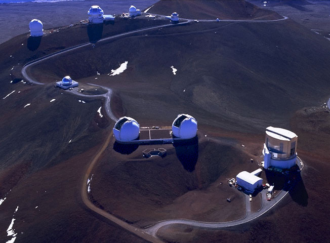
Mauna Kea Telescopes

 Photo Credit

Mauna Kea is a really awesome place to visit. I had the chance to visit the telescopes.  I talked with astronomers but not the locals. I had no idea about the sacredness of the area until reading this weeks’ lesson.  I was struck by how it wasn't mentioned in the “astronomy world.”  The indigenous beliefs explains the placement of some of the scopes.  The astronomers talked about Hawaiian star navigation but not about the sacred ground.  I was very struck by the fact that no alters or other artifacts are found in certain areas of the mountain because it is considered too sacred for humans.  We should all respect that!
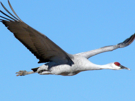

 Crane photo credit

I recently used the ruler tool on Google Earth to have students track crane migration.  I gave them the GPS coordinates and they had to measure how far the cranes flew and how long the trip took.  The students were amazed at how far they traveled – it was a fun way to get them to do the measurements and adds that “wow” factor. 

Extend

Incorporating tsunamis, volcanoes, and earthquakes can help make science more interesting to students and adults alike.  There are so many ways to use this info.  For example, the  Alaska Volcano Observatory has real time and archived data that can be mapped on Google maps or followed sequentially.  I plan on using this along with weather sites and Google Earth for the aviation portion of our ACE Academy.  What a great set of resources for the students to learn about the impact of volcanoes on all aspects of life, especially if you are a pilot!
·          
Google Earth is awesome for geology, GPS, migration, travel, math, weather patterns and spacial understanding – it’s going into lots of my cross curricular lessons from geology to aviation.


Evaluate
Google Earth is such a neat tool that can be used in so many ways.  Every time I am re-introduced to it, I learn more and start brainstorming about the possibilities.  What a neat way to look at cataclysmic events as they are occurring and map them out . A great way for students to look at locations and times of occurrence of the current eruptions in the news,  then try to put together some hypotheses about if or how they are related.  This is a great inquiry opportunity for students of all ages – and for adults as we speculate about what all this means!  This would be a great cross-curricular activity to bring into social sciences.  Students could investigate how these events are currently shaping the lives of people who live in the shadow of a volcano or the path of a potential tsunami like in Lituya Bay.

3 Colleagues
This week I am commenting on
Amy Peeke

Kristina Owens

Doug Armstrong


Sunday, October 24, 2010

Module 3: Landscapes!


Explain
Geology is one of my hobbies (ok, I have rocks all over the inside and outside of my house) so I was excited to check out the resources and information for this module.  The description of Alaska really helps explain the active geological processes that continue to occur under our feet. As I flew back home over the Wrangell-St. Elias mountain range yesterday, I was in awe about how much it continues to rise each year!

Mt. Redoubt erupts!  2009


I am struck by the impact of satellite photos and technology on the views of the geologic forces of the earth.  Geologic forces are, in general, slow acting and long reaching and thus hard to comprehend on a human scale.  Being able to see an area from far away on Google Earth, and put it in the “big picture” of the land around it certainly contributes to our understanding of the geologic forces and cycles, and how they influence the ecology as well as the culture and economy of an area.  

An example of this is  Machu Picchu. I have read about it and seen photos, but looking at it on Google earth gives a different perspective.  How did the Incas manage to build all that with the available technology?   Another example of seeing the “big picture” is Cahokia Mounds state park near St. Louis, MO.  Looking from Google Earth, you can see why the ancient Americans build their city here near the river and the crossroads for traveling tribes.

Extend
The maps and animations will be used with our climate change curriculum on our new Magic Planet (a globe –like projection screen.   Several in the list below will be awesome on the globe!  For example, students and community members could see why Alaska has so many earthquakes and volcanoes.

This material will also be used in my home school science program. The links provide students a quick way to explore the types of plate movement, how the rock cycle works, and locations of plate boundries, volcanoes, and earthquakes.  I like letting students use the on line resources because it helps engage reluctant readers and students can go through them at their own pace.

Evaluation
The material in this unit is very relevant for developing an interactive display for looking at plate movement and geological phenomena in Alaska and around the world.  The geologic forces certainly influence the way of life here, from the ancient culture to today’s oil- dependent culture.

Being able to look at the “big picture” helps understand the development of cultural activities and traditions of indigenous peoples.  The landscapes determine the ecology of the area.  The ecology determines survival strategies, including choices of food, shelter, travel, and commerce. 

Pt. Hope, AK: modern and ancient economies together

 
Links for reference
I am listing my favorites so that I can refer back to them or others who might be interested can find them quickly! 

Climate change and weather patterns and how they affect traditional Arctic lifestyles and hunting

Mountain maker, earth shaker simulation – good simulation that shows the various plate movements, mountain formation, volcanoes at plate boundaries and their effects at the surface of the earth

Rock cycle animation – simple animation showing the three main types of rocks and how they are formed (middle school)

 Volcanoes around the world- good map of where they are located – for Magic Planet?

Animations and explanations of plate tectonics (long website but great animation and accompanying explanation)
http://www.google.com/imgres?imgurl=http://www.k12science.org/curriculum/musicalplates3/images/plates.jpg&imgrefurl=http://www.k12science.org/curriculum/musicalplates3/en/studentactivity2PRINT.shtml&usg=__zuYoXBnZzn-qeiE9WGQxu_3Dm_0=&h=780&w=404&sz=107&hl=en&start=17&sig2=OiW3D52UlSZPC8kGjM-emQ&zoom=1&itbs=1&tbnid=vnwasJ1z4tfaaM:&tbnh=142&tbnw=74&prev=/images%3Fq%3Dtectonic%2Bplate%2Blocation%2Bmap%26hl%3Den%26sa%3DG%26tbs%3Disch:1&ei=CkHCTNXkKIeglAfcqKAH


Sunday, October 17, 2010

Module II: Connections!

Course Module II
Everything is connected! One of the first things I teach in science when discussing food webs and ecosystems. I like to do an activity where you unroll a ball of yarn while passing it randomly from student to student.  Then take one student out – what happens?  Great visual for kids from K through 12.  I will be looking at doing a similar activity for our climate change curriculum that I am currently developing.  I can see having kids be a part of the earth systems, and using a connection between the different systems kind of like a concept map.  (When I get a more concrete idea I will post it!)

I agree that is it important to teach the inter-relationships between subjects in middle and high school.  I have had high school students say, “You think your class is more important that all the others” and in a way, I want to say, “of course - science is the best!”  But then a student will say, “Why are we doing math?  This is science” or “why do I have to write something?  This is science.”  That is where they begin to see an interconnection and is a good place to emphasize the fact that all subjects are related, even though they are taught by different “experts” at the high school level.  And of course we all think our class is the most important, otherwise we wouldn’t be teaching it.  But at the same time teachers realize that they are all interconnected and that each subject plays an important role in the student’s development and understanding.  I would like to see more collaboration between departments in high schools, and I know there are some programs that do that.  As a teacher, I would like to see how students think in other subjects besides science because it gives me an insight into how to make science topics relevant and understandable.

I like the idea of Silla or Spirit.  I think everyone has a basic belief and understanding of Silla although we may call it different things.  I like the idea of connectivity and being a part of something bigger.  In science, all concepts are part of a bigger cycle or concept and this is a great way to introduce tying them together. 

I will use some of the video clips in the teaching resource in my science classes as a good introduction and discussion starter.  It saves a lot of time and helps me focus on the point of the lesson (as you see, I can tend to ramble easily…)

The People of the Arctic video and accompanying material will be great to use in the ecosystems section of our home school science program.  I teach a lot of kids who are “urbanized” and spend a lot of time inside with electronics.  This is a way to introduce them to the world outside their door:  Alaska is full of science wonders that many students never see!  I like the videos because they present a different view point than what I can present as a “native Caucasian” to the students. 

When I started reading materials for this unit, I thought of string theory.  I have to say I do not understand it (nor do I really understand relativity but I am working on that!) but it is a way that ties everything in the universe together – just like the food web and the yarn.  I recently read “The Secret” as self- help kind of book that basically reiterates the same thing: all energy is tied together; all energies we generate and use affect other energies and affect other things.  The effect may vary, but once again the message is that all things are intertwined. 

I love the Symphony of Science website. Not sure how I first found it, but I really like their messages, and how they have famous scientists that the kids might not necessarily know, such as Carl Sagan.   I have not used these in classes or workshops yet, but have put links to them in my weekly newsletter.

This is a very relevant and insightful module, especially since I am starting development of a climate change curriculum.  What better way to show interconnections between all things?  I will certainly use the material in the program.

Comments on other’s blogs:
This week will review/comment on:

Marilyn , because I love Gustavus

I really enjoyed reading your blog!  I agree that integrated science is a great way to teach.  I never liked the traditional "order" of science, that many high schools have, where students take biology, then chemistry then physics.  They should all be taught together somehow because the same basic principles apply to all. I taught a 9th grade integrated science class and maybe that's a good way to start to tie things together, then to become more specialized in the other branches of science.

I spent two weeks with my family in Gustavus several years ago (stayed at Amy's Smoke House).  My 3 kids were in elementary school, and we had so much fun exploring the area around town.  They had their break-up boots and spent hours in the river and the beach at Glacier Bay.  My youngest son (my adventurer) had his first face to face encounter with a moose (they were both walking through the tall grass and didn't see each other), got a bear between me and him (the bear was interested in strawberries and not small children), and lost his boots in the mud on the beach as I pulled him out just in time!

Great memories of a beautiful place!

Mary, because I spent a week in Newhalen last spring for School Bus to Space
Hi Mary,
I was in Newhalen last March with School Bus to Space….I spent a lot of time with the kids where were a little bit older, but I had a great time there.  I was there during a thaw so got to see the beautiful tundra and colors you have described.  In fact, the kids were refereeing to me as the lady who takes pictures of the ground because I would go out walking with my camera after class taking pics of the tundra (they also thought I was a little strange for doing that!) 

I had a chance to meet and talk with some of the elders in the area, both at lunch time in the school and while walking around.  What a great resource to have, although like most things, the kids don’t always realize how valuable it is until much later.  I don’t really have access to that kind of resource here, but would like to make some connections so that perhaps some of the local elders could come and share with students how things have changed recently.  


Winsor, because I share her love of Homer Spit and dogs!
Hi Winsor,
I am a native Coloradan and also grew up there.   I enjoyed reading about you and your furry friend on the beach at Homer.  I have taken one of my labs there, and can totally relate to the adventures with your dog!  I agree the Homer Spit is one of the most beautiful places on earth.  There is nothing like watching the birds come and go from there – any time of year you can see something flying around (ok, birders, I know that’s a very generic thing to sayJ)  My dog also loves the smells and to run up and down the beach.  I see your dog also likes large sticks, aka tree trunks.  Ben tries to bring them to me on a regular basis – don’t know why he doesn’t pick up a stick he can carry!

The Homer Spit has a lot of history to it, and I think will be one of the places on the Kenai Peninsula that will be most impacted by climate change.  In developing climate change curriculum for our center, it is definitely a place to include and to monitor.  Most of the students around here at least know where it is  and many have been there, so it is a great reference point for them to think about how things like changing weather patterns and sea levels might have an effect.  And they can study the effects on the landscape and the wildlife - including the impact humans have such as the Eagle Lady.  Not saying it’s good or bad, but it’s a great example of the impact humans can have on animal behavior and how once again, all things, including humans, are intertwined!

What a great way to get to know your “digital classmates!”  

Friday, October 15, 2010

Where on Google Earth was I born?

I was born in the city of Denver, Colorado.  I don't think of "landscapes" when I think of Denver.  Instead, I think of "manscapes" or land that has been shaped by humans.  I grew up there, and learned about the climate and geology around Denver, but somehow in the urban and suburban world I don't think of landscapes.

Denver is located on a high altitude plain.  It is next to the Rocky Mountains, and has a beautiful view of the mountains (when the brown cloud is not there!).   Before the city, it was a prairie; dry grasslands that can still be seen to the east of Denver in some areas.  It is dry, but does get snow in the winter.  Geologically, it is not very active right now.  When the Rocky Mountains were formed, it must have been a "rockin" place - lots of shifting and moving of the landscape.

Humans have changed the landscape in many ways.  The most obvious is the buildings and roads that cover the area.  The waterways have been changed, too.  Rivers and streams have their paths altered to reservoirs or to route them around neighborhoods, buildings, and other structures.  Man has added trees and the lawns and gardens that are watered year round make the landscape much greener that it used to be.  (That is a good thing, although it is still altered!)

 I guess my birthplace landscape is a city, with tall buildings, roads, trees, and people.  In some ways the city is a beautiful landscape, however, I prefer the landscapes where I live now in Alaska!

I'm not sure how to post a link to the place in Google Earth.  I was able to email a link to myself, but I don' see how to put it in the blog, or how to copy an image into the blog.  Hmm......I have a lot to learn about blogging!  Meanwhile, I will see if I can figure it out before Monday am. 

Ah ha....found a solution.  What did we do before Google????  Google (and the technology of the internet) has drastically changed the way myself and my students view the world and access information.  With Google Earth, you can get a real perspective of where you live in relation to the entire globe, and a perspective of how large or small the place you live is.  It allows people to see places they could never see otherwise, and get a view of the world that was only possible through a vivid imagination in the past.  I really like the feature where you can look at historic photos and maps and compare them to what is there now. What a neat way to document changes - both from a social perspective and a scientific perspective.

Sunday, October 10, 2010

My Favorite Place

Living in Alaska, I have many favorite places as there are too many neat things to see here.  But I am putting up a picture of Denali.  I love the park and love going there because it is always beautiful and you never know what you will see.  No matter what the weather, the park has a character of its own.  I have never been there in winter, but one of these days maybe I will get the chance.

I really fell in love with the park when my youngest son and I worked a couple summers pulling dandelions.  It was a chance to be "intimate" with the park as we spent days walking through the park pulling weeds.  At the time my son was kind enough to go along with me, but it was a wonderful experience that I shared with him and will remember always.

I am trying to upload a photo and it won't take.  I see in the blog help area that I am not the only one with that problem and they are working on it (since August!).  Meanwhile, close your eyes and imagine a beautiful snow covered mountain emerging out of a green valley covered in sunshine!